
South Africa Weather Warning: 7 Areas Facing Storms, Flooding and Strong Winds
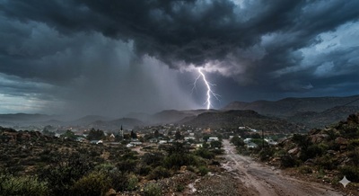
South Africa is facing another unsettled day of severe weather, with thunderstorms, heavy rain, damaging winds and possible flooding expected in several parts of the country on Tuesday, 15 September.
South Africans in several provinces are being urged to stay alert as a series of weather warnings remain in place.
The South Africa weather warning comes as the South African Weather Service (SAWS) forecasts widespread showers and thunderstorms across parts of the country.
Some areas face the possibility of localised flooding, strong winds, excessive lightning, damage to infrastructure and disruptions to roads and services.
For commuters, motorists and people living in vulnerable areas, the weather could make Tuesday a particularly difficult day.
Here are seven areas to watch.
1. Gauteng could see thunderstorms and difficult driving conditions
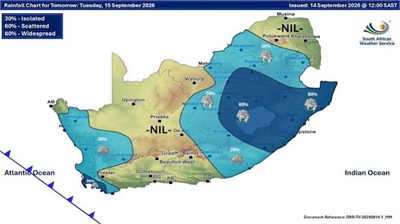
Gauteng is expected to experience partly cloudy, windy and cool-to-warm conditions, with isolated showers and thundershowers.
Johannesburg is forecast to reach around 22°C, while Pretoria could reach approximately 24°C.
Although not every part of the province will receive heavy rain, thunderstorms can develop quickly.
Motorists should be particularly cautious when visibility drops or roads become wet.
Standing water can also become a hazard, particularly on roads and low-lying routes that already struggle to drain after heavy downpours.
2. KwaZulu-Natal faces thunderstorms and strong coastal winds
KwaZulu-Natal is also expected to experience scattered showers and thundershowers.
The weather service has warned of strong winds and waves along parts of the coast and adjacent interior.
This could create problems for small vessels, harbour operations and communities close to the coastline.
Durban is expected to remain partly cloudy with scattered showers and thundershowers, with temperatures ranging between approximately 20°C and 25°C.
People heading to the coast should keep an eye on changing conditions rather than assuming that a cloudy morning will remain calm throughout the day.
3. The Free State could see scattered thunderstorms
The Free State is expected to be partly cloudy, windy and cool to warm, with scattered showers and thundershowers.
Bloemfontein is forecast to reach around 19°C.
The combination of thunderstorms and wind could create difficult conditions for motorists, pedestrians and communities in vulnerable areas.
People travelling between towns should allow extra time and avoid unnecessary travel during the worst of the storms.
4. North West is another province to watch
The North West is expected to experience partly cloudy, windy and cool-to-warm conditions, with showers and thundershowers in parts of the province.
Mahikeng is expected to reach around 24°C.
The weather service has also warned about damaging winds in parts of the province.
Strong winds can bring down trees, damage structures and disrupt electricity and communications.
Residents should secure loose outdoor objects before storms arrive.
5. Northern Cape could experience more disruptive conditions
The Northern Cape is among the areas facing more significant weather concerns.
Cloudy and windy conditions are expected, with showers and thundershowers in parts of the province.
Some areas could experience heavier rainfall.
There are also warnings related to disruptive rain and flooding in parts of the Northern Cape.
People living in low-lying areas should be especially cautious if heavy rain develops.
Do not attempt to cross a flooded road simply because the water appears shallow.
6. Western Cape faces rain, storms and rough conditions
The Western Cape is also being affected by the unsettled weather system.
Cloudy and cool-to-cold conditions are expected, with showers and thundershowers in parts of the province.
SAWS warnings include severe thunderstorms in parts of the province, with excessive lightning posing a risk of injuries and service disruptions.
Rough seas and strong winds could also affect coastal areas.
Cape Town is expected to experience cloudy and cool conditions, with the possibility of rain.
7. Eastern Cape and Limpopo aren’t completely in the clear
Parts of the Eastern Cape are also expected to experience scattered showers and thunderstorms.
The northeastern coast and adjacent interior have a severe-thunderstorm warning in place.
Limpopo, meanwhile, is expected to experience partly cloudy conditions with isolated showers and thundershowers in some southern and southwestern areas.
The weather will therefore vary significantly from one part of each province to another.
That makes it important to check the forecast for your specific town or municipality rather than relying only on a province-wide forecast.
What should motorists do during severe thunderstorms?
If you are driving when a severe storm develops, slow down.
Heavy rain can dramatically reduce visibility, while water on the road increases the risk of losing control.
Keep a safe following distance and avoid sudden braking or lane changes.
If conditions become dangerous, find a safe place to stop rather than continuing simply because you are trying to reach your destination.
Never drive through a flooded section of road when you cannot determine how deep the water is.
A road that looks passable can conceal washed-away surfaces, potholes or strong currents.
What about lightning?
Thunderstorms also bring a significant lightning risk.
If you are outside when lightning develops, move indoors if possible.
Avoid standing underneath isolated trees and stay away from exposed open areas.
People working outdoors, sports participants and livestock owners should take particular care when thunderstorms are nearby.
Lightning can strike even when the storm does not appear to be directly overhead.
Why the weather is changing so quickly
September is a transition period in South Africa as winter gives way to spring.
That transition can produce rapidly changing weather patterns, particularly across the interior and eastern parts of the country.
Warm air, moisture and developing weather systems can combine to produce thunderstorms, strong winds and heavy downpours.
That is why a relatively calm morning can turn into a stormy afternoon.
The bottom line for South Africans today
The latest South Africa weather warning is a reminder that residents should not treat thunderstorms as simply another rainy-day inconvenience.
Depending on location, today’s weather could bring heavy rain, lightning, strong winds, flooding and disruption to roads or services.
If you live in an affected area, check the latest SAWS updates before travelling and pay attention to local warnings throughout the day.
For motorists, the safest approach is to slow down and avoid flooded roads.
For people at home, secure loose objects, stay indoors during severe lightning and keep emergency contacts available.
And if your area is prone to flooding, do not wait until water has already entered your property before taking precautions.
South Africa’s weather can change quickly. Stay informed, stay cautious and take official warnings seriously.